
What this helps you see
Choose region boundaries or coordinates according to what each record represents. A store belongs to a point; a provincial rate belongs to the corresponding administrative region.
Free example data and exact column mapping
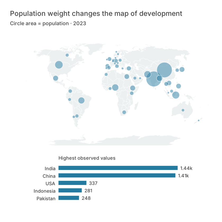
The figure uses the downloadable CSV with the exact column mapping below. Public snapshots retain their data notes and transformations. Constructed teaching scenarios are identified in the method notes; they are not customer results. Editorial layouts may combine comparisons from the same records.
The free example contains 48 observations and these columns: ISO3, Income (USD), Life (years), Population (m), Latitude, Longitude, Economy, Continent. Keep the header row and preserve one observation per row. The table below shows the first records; the CSV retains the full example.
| ISO3 | Income (USD) | Life (years) | Population (m) | Latitude | Longitude | Economy | Continent |
|---|---|---|---|---|---|---|---|
| ARE | 49850.6945082084 | 82.909 | 10.483751 | 23.90927859875184 | 54.2971454388171 | UAE | Asia |
| ARG | 14261.8465667948 | 77.395 | 45.538401 | -34.68519584440964 | -64.76354412795912 | Argentina | South America |
| AUS | 65058.3773146674 | 83.0512195121951 | 26.659922 | -25.764019827613637 | 134.30370851350128 | Australia | Oceania |
| AUT | 56579.504175468 | 81.7926829268293 | 9.131761 | 47.592333826435514 | 14.111392235962336 | Austria | Europe |
| BEL | 55244.68145811 | 82.4 | 11.779946 | 50.64016971234367 | 4.646175091955645 | Belgium | Europe |
| BGD | 2551.01773827307 | 74.672 | 171.46699 | 23.860318325578753 | 90.24720523537584 | Bangladesh | Asia |
How to use it in Datamon
- Choose Map when creating the visualization, then import region identifiers or latitude and longitude.
- Select the intended boundary geography and review unmatched names or codes before interpreting the map.
- Choose among regional, point, bubble, cluster, density, flow, bivariate and category views as the data permits.
- Check the legend, units, missing-data appearance and coordinate privacy before exporting or publishing.
Column mapping
- Value
- Population (m)
- Latitude
- Latitude
- Longitude
- Longitude
- Location label
- Economy
How to read the example
Compare positions and values with the table, then inspect the legend or size encoding where used. A visual pattern is a description of the displayed observations. It does not by itself identify a cause, justify extrapolation, or repair missing data.
Limits and common mistakes
A matched name does not prove identical geographic coverage. Spatial controls and connected analysis depend on the operation and configured deployment; do not infer risk from point density alone.
What is free and what needs an account?
Reading this guide and downloading its CSV and chart images are free. Datamon currently has no paid checkout or subscription plans in this deployment. Creating and saving an editable visualization requires Google sign-in. Provider-backed AI, cloud analysis, publishing and video depend on configured services; this guide does not promise unlimited free connected services.
Questions before you start
Can I visualize geospatial import and regional mapping with a free example?
Yes. The CSV and preview images on this page are free to download. Follow the field mapping and steps above. Sign in to create and save the editable project; connected-service availability is separate.
Can I replace the example with my own data?
Yes. Preserve the observation unit and the required numeric, category or geographic fields. Recompute any derived values, update the unit and source, and compare the output with known rows before sharing.
Sources and further reading
Report a correction or an access barrier: Email the editorial contact.
Open Datamon